Rendering well data has never been easier! Voxler 3 can now render straight and deviated well bores in true 3D space. Once a well path is modeled, you can render from-to data, wire-line logs, curves, and directional survey data along the well path. Multiple variables can be rendered along the well paths simultaneously.
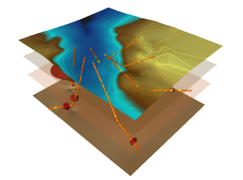
Combine 3D well data, topography, and isosurfaces to outline an ore bodies in a mining area.
3D Volumetric Modeling with Volumetric Calcualtions
Generate 3D Isosurfaces from your gridded point dataset and now calculate the volume above or below the specified isovalue.
Label Scatter Plots by any X, Y, Z, C or Text Values
Labels can now be displayed on the points of the ScatterPlot module. You can label your scatter plots by the X coordinates, the Y coordinates, the Z coordinates. a combination of all coordinates, any specified component values, or a text or data value from a label column in the source dataset. All labels have full formatting and editable font options.
3D Volumetric Modeling has Been Expanded in Voxler with the Addition of a New 3D Block-style Model
Using Voxler's new FaceRender module, you can display true voxel data in a 3D block model. Display specific ranges of your data, count the number of blocks, calculate the average block value, and most importantly calculate the volume of the specified value range of your data. This module could be extremely helpful when you are trying to model a sub-surface ore body in 3D and estimate a volumetric calculation of the subsurface body.
Clip multiple graphical display modules at the same time
Voxler's enhanced ClipPlane module now accepts multiple inputs to save you time and effort clipping multiple graphical display modules at the same time. Only set the clipping parameters once!
Expanded File Support
Voxler can now import and export Excel XLSX files. Import file support has been added for LAS files and ER Mapper's ECW files. Voxler can also now export ZMAP and CPS3 grid files.
Drape Imagery over 3D HeightFields
Voxler 3 now allows you to drape satellite and aerial imagery over 3D HeightField surfaces. We have added even more flexibility to Voxler by allowing this highly requested functionality to be compatible with Surfer-generated GRD files and by using superior texture mapping algorithms to fit the image to the surface.
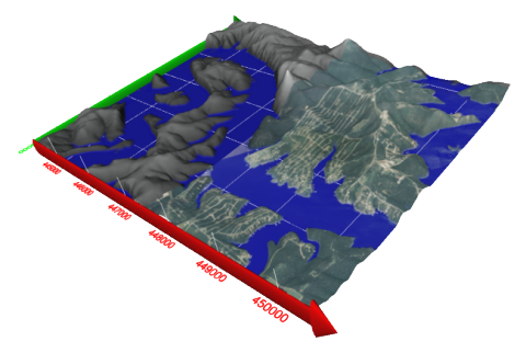
Drape georeferenced imagery over a Surfer® GRD file in Voxler 3
The User Interface is Now More Friendly
Many enhancements have been added to Voxler 3 to increase usability. We have added an exceptionally organized Property Manager to the interface that allows you to quickly find and manipulate the properties you are looking for. We have also added a number of highly-requested module behavior enhancements to the Network Manager, which allow for increased network management. Click and drag all Voxler project files and data files onto the user interface or Voxler icon for rapid loading and importing. The Viewer Window now supports tabbed windows so you can quickly go back and forth between multiple views of your project.
Voxler 3 is much faster with the addition of Multithreaded Processing
You will undoubtedly see the increase in performance of Voxler 3; we have added multithreaded processing to almost every aspect of the program. Voxler 3 will now take advantage of SMP architectures for many of its processing algorithms.
Exporting 3D Gridded Data to a Single Data File
Voxler 3 now allows a much more streamlined export of lattices and 3D gridded data by supporting a single XYZC datasheet to be exported from the Gridder in XLS, DAT, CSV, and TXT formats.
Transforming Data in Voxler's Scene is Now More Flexible
The transforms in Voxler have been completely overhauled to add much more usability and flexibility. Transformations are not just starting at the data's midpoint and moving out in equal directions. You can now specify the origin where you want the transformation to start. The Axes are now scaled along with the transformations, so no more stretched axes.
Convert Data from Wells and Lattices into 3D Point Clouds
Use Voxler's new ExtractPoints module allows you to quickly convert data from multiple well data sources into a single XYZVC Point Cloud. The point data can then be gridded and then rendered using any of Voxler's graphical display modules. Lattices can also be easily converted into a XYZC point set using this great addition to Voxler.
Drape Contours over Surfer Grid Files
Voxler 3 now renders contours directly from Surfer GRD files and drapes them over HeightFields in true 3D space..
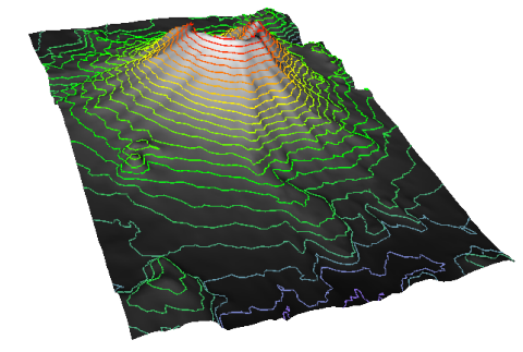
Voxler now drapes contours over Surfer grids.
Increased Range in Automation Controls
Repetitive tasks have never been easier to automate on Voxler with the newly updated version of Scripter that ships with Voxler 3. Transparency and view characteristic controls have also been added to Voxler's automation model. All new features, including well rendering, can be fully controlled from a script.
Display Cross-sections that were Generated from Strater 3 in 3D Space
There is a direct link between Strater 3 and Voxler 3 where cross-sections that are created in Strater 3 can be directly exported, displayed, and rotated in Voxler's 3D scene.
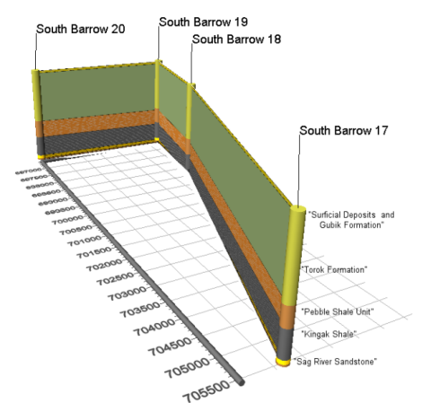
This cross-section was created in Strater 3 and then directly exported to Voxler 3 to create a 3D fence diagram.